The post Data Collection Simplified with New Measure2 App appeared first on Laser Tech.
]]>LaserSoft Measure2 App Modernizes Laser Tech’s Cornerstone Catch-All Solution for Data Collection
The Measure2 app bridges versatile TruPulse rangefinder measurement capabilities with the convenience of a mobile app. Users can capture a horizontal distance, slope distance, or vertical distance with one shot of their TruPulse laser. The same goes for inclination and angle values. Meanwhile, height measurements, missing line calculations, and laser offset GPS positioning routines require multiple shots. In any case, the Measure2 app helps make life easier with step-by-step instructions included for all measurement options, complete with graphic prompts and instant feedback. All the while, the Measure2 app digitally records every bit of data captured by each laser measurement. Users wind up with neatly organized and accurate digital reports while saving time and removing some human error in the process. Additionally, the Measure2 app deploys an all-new over the air (OTA) update feature that helps keep TruPulse i-Series rangefinders up to date with the latest firmware edition.
The LaserSoft Measure2 app is a free catch-all data collection solution designed for use with Bluetooth-compatible TruPulse laser rangefinders.
Another advantage that Measure2 app users will enjoy is the ability to command their TruPulse rangefinder from the app. Using the app’s remote-fire option, as opposed to physically pressing the rangefinder’s fire button, can help boost the accuracy of measurements. The Measure2 app can also automatically place a connected TruPulse laser into whichever mode is best suited for each measurement. This removes any need for users to select the proper measurement or targeting option themselves. Users can also enhance their data by including notes and using their Android device’s camera to add photos. At the end of the day, comprehensive reports are ready for sharing right from the user’s phone or tablet. A variety of popular file types are available when exporting. This makes it easy for users to import Measure2 data into other programs for further analysis.
“Our most popular and streamlined data collection app has received a much-needed update. In addition to accommodating the new TruPulse i-Series products, we have added the option to update the firmware on your new laser right from the app. Our users are going to love the new features we’ve added.”
-Steve Colburn, Applications Developer and Training Specialist at Laser Tech
Visit LaserTech.com to review specifications and download the LaserSoft Measure2 app for free via the Google Play store.
About Laser Tech
Laser Technology, Inc. is a Colorado-based manufacturing and design company for innovative laser-based speed and distance measurement instruments to address real-world needs and applications. Laser Tech’s TruPulse® laser rangefinders allow field crews to accurately measure distance, height, and elevation safely and efficiently. When paired with Laser Tech’s LaserSoft® apps, professionals can easily streamline workflows and document every measurement captured. Learn more at www.lasertech.com.
The post Data Collection Simplified with New Measure2 App appeared first on Laser Tech.
]]>The post TruPulse 200𝗂 Release Sets a New Standard for the TruPulse Line appeared first on Laser Tech.
]]>
The Next-Generation’s Standard is Set with Laser Tech’s Release of the New TruPulse 200i Laser Rangefinder
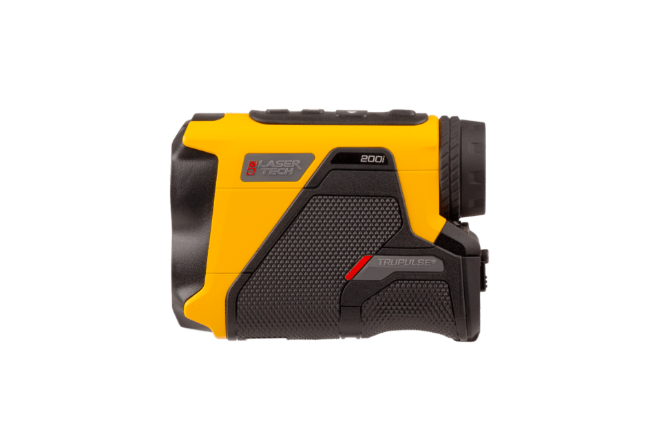
Laser Tech’s release of the TruPulse 200i sets a new standard for the TruPulse line by encompassing customer feedback into an updated design, a more intuitive interface, and the same reliable performance users expect.
CENTENNIAL, CO, June 26, 2024: Laser Technology Inc. (LTI), manufacturer of the original TruPulse®️ laser rangefinder, proudly announces the release of the new and improved TruPulse 200i.
Found in toolkits worldwide, the TruPulse 200 set the standard in professional-grade handheld measurement devices for years. As a next-generation model, the TruPulse 200i pushes the signature tool forward with significant advancements made in distance and inclination accuracy, Bluetooth® wireless connectivity to any device, and a ruggedized and waterproof exterior.
“The TruPulse 200i laser rangefinder embodies our passion for simplifying life in the Professional Measurement arena and sets a new standard for our world-renowned TruPulse line, ushering in the next generation of handheld precision measurement.”
–Derrick Reish, Laser Tech Global Senior Product Manager
“Users will achieve higher accuracy while enjoying ultra-quick acquisition and a more streamlined interface than you can find in any previous model. Several more feedback-based updates highlight the improved user experience, such as expanded Bluetooth performance for pairing with any device.”
Expanded Bluetooth capabilities make it easy to sync the TruPulse 200i with any device.
-Jordan Vermillion, Laser Tech Director of Marketing
The TruPulse 200i offers reliable specifications in several areas of performance:
- Distance accuracy to targets within 1,000 meters increased by 50%
- Maximum range to reflective targets increased by 25%
- Inclination accuracy increased by 60%
- HUD light transmission increased by 60%
Updates to the improved design and user interface incorporate customer feedback:
- Rugged, waterproof housing withstands everyday use and harsh conditions
- Faster target acquisition with physical, visual, and audible feedback simplifies use
- Adjusted button layout introduces Menu and Accept buttons for streamlined navigation
Visit LaserTech.com/product/TruPulse-200i to review full specs and request a quote on the TruPulse 200i.
About Laser Tech
Laser Technology, Inc. is a Colorado-based manufacturing and design company for innovative laser-based speed and distance measurement instruments to address real-world needs and applications. Laser Tech’s TruPulse® laser rangefinders allow field crews to accurately measure distance, height, and elevation safely and efficiently. When paired with Laser Tech’s LaserSoft® apps, professionals can easily streamline workflows and document every measurement captured. Learn more at www.lasertech.com.
The post TruPulse 200𝗂 Release Sets a New Standard for the TruPulse Line appeared first on Laser Tech.
]]>The post TruPulse 360𝗂 Release Unveils Latest 3D Rangefinder appeared first on Laser Tech.
]]>3D Rangefinder Technology Refined for Next-Generation with Laser Tech’s Release of the new TruPulse 360i
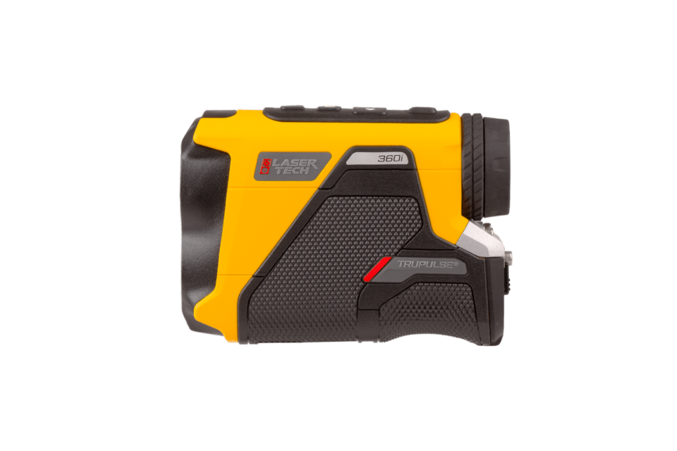
Laser Tech’s release of the TruPulse 360i marks a new chapter of intuitive and user-friendly compass-fused rangefinder technology.
CENTENNIAL, CO, June 26, 2024: Laser Technology Inc. (LTI), the world’s leading manufacturer of professional-grade laser rangefinders and makers of the original TruPulse®️ series, proudly announces the release of the new and improved TruPulse 360i.
This next-generation version of Laser Tech’s TruVector® compass-fused TruPulse 360° rangefinder enhances the most advanced handheld laser rangefinder on the market. Faster target acquisition speeds accompany increased accuracies for distance and inclination to bring the powerful tool to new heights. A modernized design adds to the user-centric experience with tactile button feedback, an ultra-bright heads-up display, and expanded Bluetooth connectivity, all while maintaining a rugged waterproof exterior.
“We are excited to introduce the professional measurement community to the new TruPulse 360i, which keeps all the best features from our previous compass rangefinder models while incorporating several customer-driven updates.”
-Jordan Vermillion, Laser Tech Director of Marketing

The TruPulse 360i includes full Bluetooth compatibility for pairing with any device.
“Users will enjoy the rugged and waterproof nature of our previous TruPulse 360°R model in a more ergonomic design. Improvements featured in this next-generation user interface reveal themselves quickly, with faster target acquisition, streamlined results analysis, and simplified menu navigation. This exciting new rangefinder also offers improved specifications from previous versions in several key performance areas.”
-Derrick Reish, Laser Tech Global Senior Product Manager
The TruPulse 360i boasts accuracy specifications that users have come to expect from Laser Tech:
- Distance accuracy to targets within 1,000 meters increased by 50%
- Maximum range to reflective targets increased by 25%
- Inclination accuracy increased by 60%
- HUD light transmission increased by 60%
Along with these technical improvements come feedback-driven updates to the user experience:
- Faster target acquisition with in-display visual feedback simplifies use
- Adjusted button layout introduces Menu and Accept buttons for simplified navigation
Visit LaserTech.com/product/trupulse-360i to review full specs and request a quote on the new TruPulse 360i laser rangefinder.
About Laser Tech
Laser Technology, Inc. is a Colorado-based manufacturing and design company for innovative laser-based speed and distance measurement instruments to address real-world needs and applications. Laser Tech’s TruPulse® laser rangefinders allow field crews to accurately measure distance, height, and elevation safely and efficiently. When paired with Laser Tech’s LaserSoft® apps, professionals can easily streamline workflows and document every measurement captured. Learn more at www.lasertech.com.
The post TruPulse 360𝗂 Release Unveils Latest 3D Rangefinder appeared first on Laser Tech.
]]>The post Laser Tech Recognized as an Esri Cornerstone Partner appeared first on Laser Tech.
]]>This acknowledgment was presented to Laser Tech for their long-term commitment to Esri and the geographic information system (GIS) community.
Laser Tech Recognized as an Esri Cornerstone Partner for 20 Years of Commitment to Esri and ArcGIS Technology
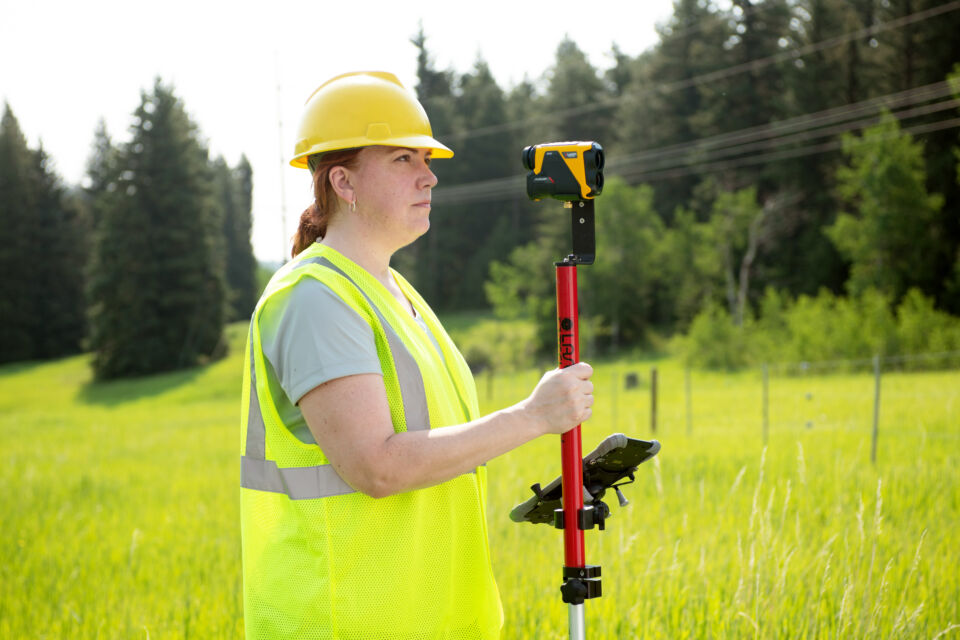
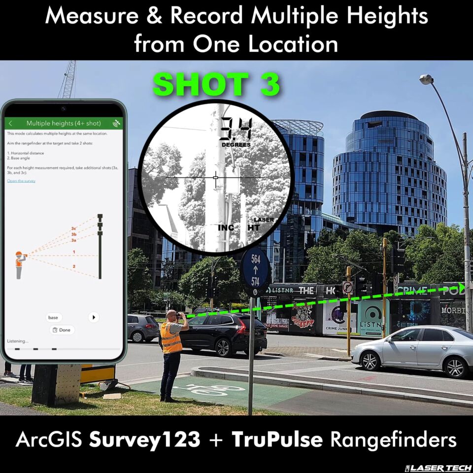
ArcGIS Survey123 user records multiple height measurements with a TruPulse 200x laser rangefinder, connected to the app via Bluetooth.
Cornerstone Partner recognition is given to organizations that have participated in the Esri Partner Network (EPN) for 20 years while demonstrating a consistent focus on helping customers succeed through the adoption of ArcGIS technology.
Laser Tech, a manufacturing company that designs laser-based speed and distance measurement tools, continues to expand the number of Esri ArcGIS apps that feature TruPulse® rangefinder integration for simplified data collection. On-board routines make it easy for users to find convenient locations to capture distance, height, azimuth, and angle measurements, complete multi-height evaluations, and perform GPS/GNSS offset positioning tasks. ArcGIS Field Maps and ArcGIS Survey123 are two leading examples of TruPulse-compatible geospatial apps that help expand the abilities, efficiency, and safety of users of all kinds.
Derrick Reish is recognized on behalf of Laser Tech for twenty years of partnership with Esri at 2024’s Esri Partner Conference
“We are thrilled and honored to be recognized as an Esri Cornerstone Partner after 20 years of working together to continue pushing the boundaries of geospatial data collection for the betterment of a hardworking, ever-expanding, and much deserving group of international users.”
-Derrick Reish, Laser Tech Senior Product Manager

About Laser Tech
Laser Technology, Inc. is a Colorado-based manufacturing and design company for innovative laser-based speed and distance measurement instruments to address real-world needs and applications. Laser Tech’s TruPulse® laser rangefinders allow field crews to accurately measure distance, height, and elevation safely and efficiently. When paired with Laser Tech’s LaserSoft® apps, professionals can easily streamline workflows and document every measurement captured. Learn more at www.lasertech.com.
The post Laser Tech Recognized as an Esri Cornerstone Partner appeared first on Laser Tech.
]]>The post Project Researcher Uses TruPulse Rangefinder for Cave Mapping appeared first on Laser Tech.
]]>Q&A with Steve Dagnall, TruPulse Rangefinder user and GNSS Mapping Specialist for Gower Bone Caves
The Gower Bone Caves of South Wales are well known within the archaeological and palaeontological community. A quick bit of research or a visit to their website makes this obvious:
“Caves of the Gower peninsula in South Wales have provided a rich source of archaeological and palaeontological discoveries. These have been of significant scientific importance, especially to the early understanding of human origins. As many of these finds included bones of fauna and humans, these sites have been referred to as bone caves.”
Dagnall is the webmaster of the Gower Bone Caves website. He is also part of an ongoing, collaborative long-term project that involves mapping caves and their entrances. In this Q&A, Degnall explains how he uses a TruPulse rangefinder for cave mapping tasks.
How did you first hear about Laser Tech and TruPulse rangefinders?
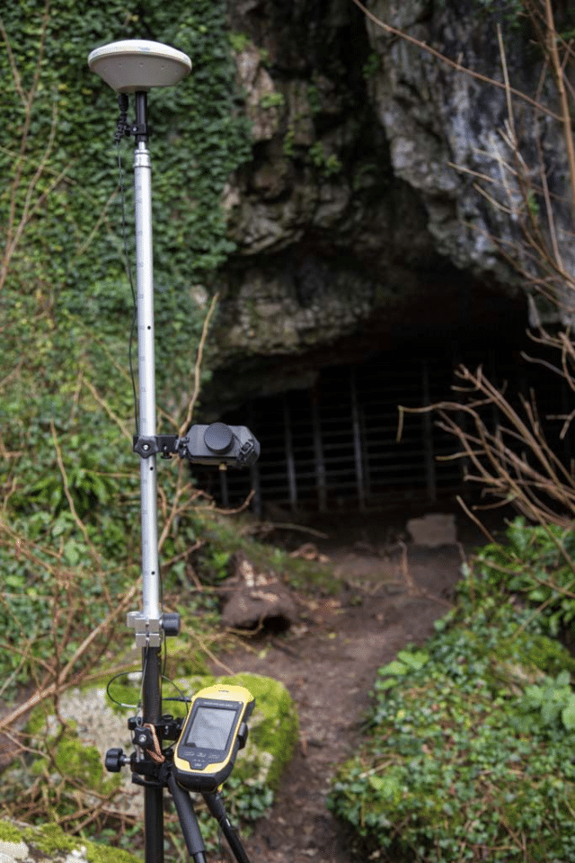
Steve Dagnall, Project Researcher working in the Gower Bone Caves, uses a TruPulse rangefinder for various cave mapping tasks.
From searching the Internet for a better solution for taking distance/bearing offset measurements than my setup at the time was capable of.
How do you use your TruPulse rangefinder for cave mapping?
The rangefinder is used to record locations of archaeological cave entrances. This task is part of a long-term personal project I’m working on with others. We’re covering an area of the UK known as the Gower Peninsula. The project also involves curating images, keeping a bibliography, and collating a digital library of appropriate documents. Many of these caves have not been accurately mapped before. Over here (in the UK), decimeter accuracy is considered good practice by the Ordnance Survey. So, that’s what I aim for.
Mapping the heights of different cave entrances is a particularly important metric. This can often become quite difficult to achieve. As these caves are mainly located close to cliff faces, and occasionally within narrow ravines, safety is a concern. There is also a high potential for bouncing signals and rarely any phone reception.
I can usually measure up to decimeter accuracy at the cave entrance just by following the Trimble guidelines for getting good, quality data. I’ll also post-process the measurements with correction data downloaded from the Ordnance Survey as a finishing touch. On the other hand, RTK (Real Time Kinematic, a technique used to increase the accuracy of GNSS signals that uses a fixed base station’s corrections) can be difficult. While it’s not impossible, the lack of a reliable phone connection can make the process tough. Whilst satellite correction data is an option, it doesn’t take long to become prohibitively expensive. This is where my TruPulse rangefinder comes into play.
In the past, I had tried using the distance/distance offset method to overcome challenges that come with error-tied bearing points. I found that the terrain in these caves did not allow for good enough geometry for this method to work. Then, I started using a rangefinder to complete distance/bearing offset routines and found success. This is now an essential part of completing the fieldwork for cave features that are difficult to safely access. I’ll also use the distance/bearing method whenever it’s impossible to record GNSS data at a feature’s location.
Do you have any favorite features?
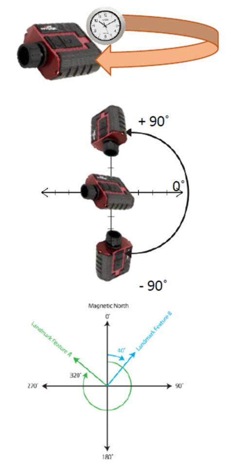
As described in the previous question, the ability to record high-accuracy distance/bearing offsets within the challenging terrain of archaeological caves. I’m also fond of how easy it is to recalibrate the instrument and the prompts I receive whenever this needs to be repeated.
Was there a time before TruPulse rangefinders were part of your toolkit?

The Gower Bone Caves of South Wales are well known within the archaeological and palaeontological community.
Yes. I used a competing brand’s rangefinder, Trimble Geo 6000 XH with a range pole, a bipod, and an external antenna.
When did you get your first TruPulse rangefinder?
Pretty recently, in February of 2023.
Have your cave mapping workflows changed since then?
Yes they have! Target acquisition is a much more precise and positive process than it was with my previous rangefinder. Now I know pretty quickly if I have made a mistake. When necessary, repeating the measurement is not such a painful process. This is especially true as the pole mount is far more stable than before. The best part is the ease with which the instrument can be calibrated.
Would you recommend a TruPulse rangefinder for others involved in cave mapping?
Yes. For sure. It is an easy unit to both calibrate and use and I am delighted with it.
The post Project Researcher Uses TruPulse Rangefinder for Cave Mapping appeared first on Laser Tech.
]]>The post TruPoint 300 Replaces Total Station for Spidercam® appeared first on Laser Tech.
]]>The high cost of traditional total stations is fair when you consider the intensely precise accuracies they achieve. However, these accuracies can often go far past the needs of an end-user. Enter Spidercam®, a “market leader in broadcast cable camera systems” who turns to Laser Tech’s TruPoint 300 to meet their accuracy needs at a fraction of the price.
TruPoint 300 for Practical Accuracy at Fractional Costs
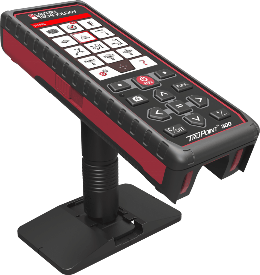
Laser Tech’s TruPoint 300 provides a practical alternative to traditional total stations
Members of spidercam decide to look for measurement equipment that might replace their conventional total stations. They see an ad for LaserTech’s “Affordable Total Station” and become intrigued. Shortly after contacting a Laser Tech partner, Spidercam receives a unit for testing. It doesn’t take long to find that this Laser Tech device is a better fit for their needs.
It is critical for spidercam to analyze the spatial characteristics of any filming location that will utilize their signature suspended-cable cameras. The TruPoint 300 helps by generating relative XYZ coordinates for several key points that a user measures to. These data points feed into spidercam’s processing software, which controls their cameras during filming. The whole process helps ensure that aerial camera movement is smooth, coordinated, and free from risk of collisions.
Daniel Paulete, Senior Project Engineer with spidercam, speaks on using the TruPoint 300:

TruPoint 300 used by spidercam
“The TruPoint 300 has replaced the expensive total station on our jobs and can do everything we need. It is easier to use than the total station and much more robust and waterproof. Not only are we very satisfied with the product, but the customer service was also excellent.
The technical support was also very available and knowledgeable. They helped me set up our new device to suit our needs and are there when you need them. Because of this experience we are looking to purchase multiple units to replace all our total stations.”
Complete Your Mapping Toolkit
Many mapping applications do not require the pinpoint accuracy of a conventional total station. In these cases, Laser Tech’s TruPoint 300 device provides an effective alternative at a fraction of the price. In addition, field crews often cite the Laser Tech device’s transportability as an added benefit. Kudos to Daniel with spidercam for seeking out a more cost-effective measurement solution for his company!
The post TruPoint 300 Replaces Total Station for Spidercam® appeared first on Laser Tech.
]]>The post TruPulse Rangefinder Handy for Mannheim Steamroller’s Audio Engineer appeared first on Laser Tech.
]]>He happily participates in a Q&A to help us learn more about how TruPulse rangefinders help make life easier for audio engineers and others working in his world of venues, loudspeakers, and live performances.
Mannheim Steamroller puts on incredibly well-reviewed live performances, highlighted for festive fans by annual Christmas tours.
They’re Kind of a Big Deal
Perhaps best known for their unique and very popular renditions of holiday classics Deck the Halls and Carol of the Bells, Mannheim Steamroller has delighted listeners since their 1975 debut album Fresh Aire. A successful run at applying their original style toward holiday classics helped Mannheim become beloved among the masses and earn their place as a staple in Christmas radio and just about every at-home Christmas collection you might come across.
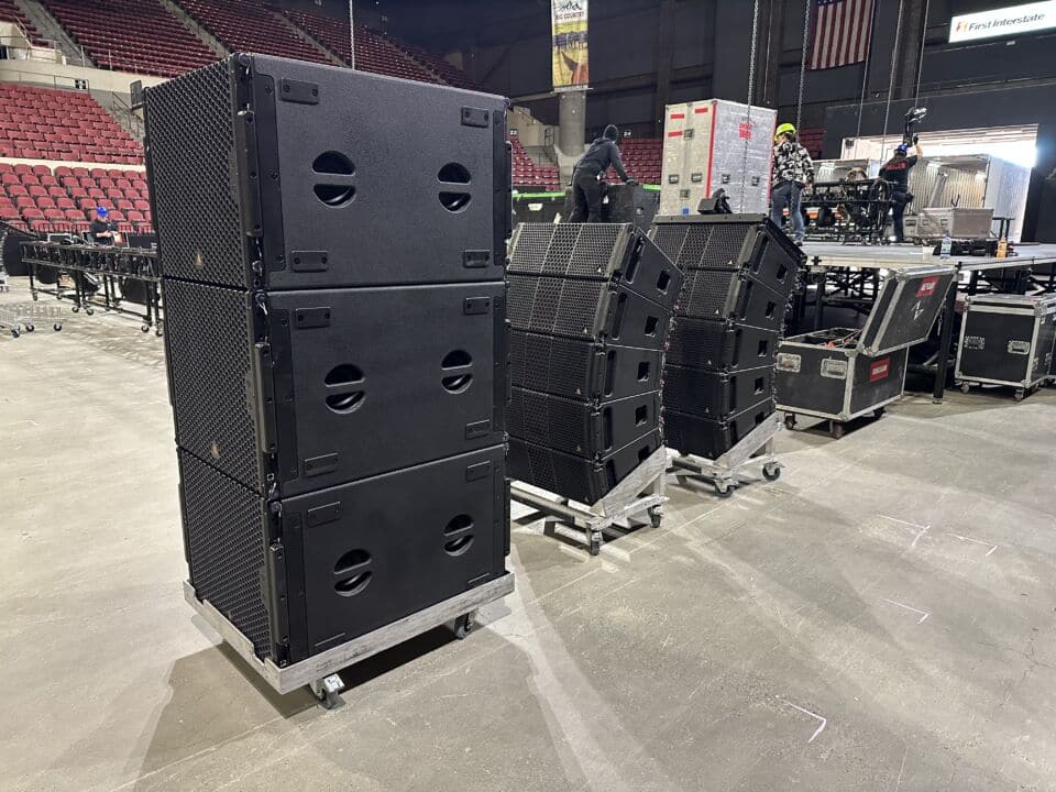
The group continues to put on incredibly well-reviewed live performances, highlighted for festive fans by their annual Christmas tours. Preparing these live shows for optimal auditory performance is where Stryker steps in, an audio engineer with a TruPulse 360° rangefinder in hand.
As an audio engineer, Stryker uses a TruPulse 360 rangefinder to make sure that each new venue is prepped for an optimal live Mannheim Steamroller auditory experience.
Q&A with Micah Stryker: TruPulse® Rangefinder User and Audio Engineer for Mannheim Steamroller
Eager to learn more about how our technology helps Micah Stryker achieve success as a Front of House Engineer for Mannheim Steamroller, we invite him to participate in a quick and casual Q&A.
How did you first hear about Laser Tech?
I first saw some Laser Tech rangefinders being used in the field about 4 or 5 years ago. This happened when I was working with a company in Omaha, NE called Audio Visions. They taught me a lot about speaker deployment and showed me how to use a TruPulse to take the necessary measurements along the way.
As an Audio Engineer, how do you use your TruPulse 360° rangefinder on the job?
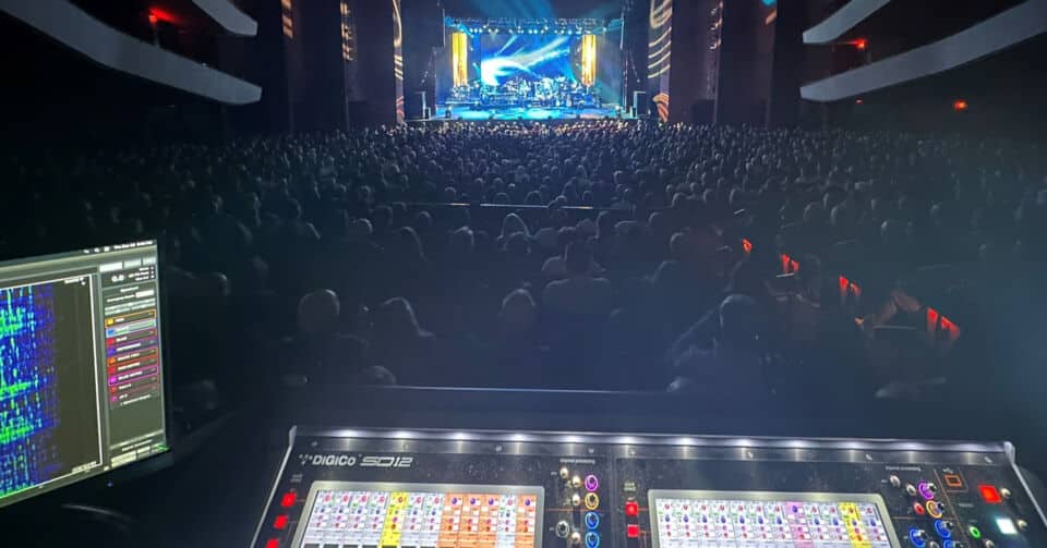
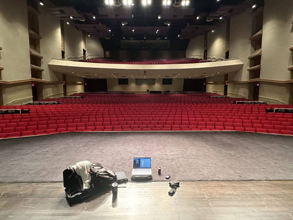
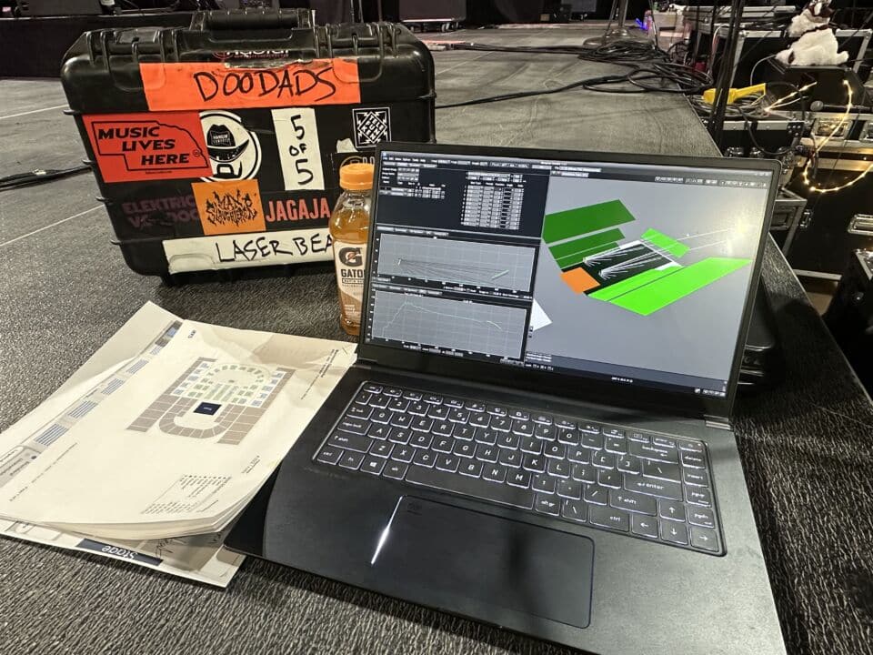
My TruPulse rangefinder makes it quick and easy to get the measurements I need in a short amount of time. This is a lifesaver when I’m on tour since there is usually a pretty limited amount of set-up time allowed each morning. I use my 360° rangefinder to get the dimensions of the different listening areas in each venue we visit. My next step is feeding these measurements into our loudspeaker coverage prediction software. This helps me determine the best setup for our sound system according to each venue’s architecture. Getting accurate measurements during this process directly translates to a better listening experience for the audiences that attend our shows.
Do you have any favorite features?
M. Stryker feeds TruPulse measurements into loudspeaker coverage software while prepping for another live Mannheim Steamroller performance.
One of my favorite features is the values showing a decimal point when the reading is more accurate, and not showing one when it is less accurate. The missing line calculation is another favorite, since it speeds things up a lot for me. It’s very handy when you have to find the inclination angle, height difference, and depth of multiple balconies in a theater, or bowls of seats in an arena. I’m also a big fan of being able to use the side buttons to toggle through the different measurements taken. The long battery life is another favorite feature!
Was there a time before TruPulse rangefinders were part of your toolkit?
There was, before I came across the rangefinders in the field. These days, the old “how many football fields away is it?” estimation method just doesn’t cut it for me anymore.
When did you get your first TruPulse rangefinder?
I’ve been using them for about three years or so now. Before I got one of my own I was borrowing one.
Have your workflows changed since then?
TruPulse rangefinders help audio engineers like Stryker discover the best placement for equipment in each new venue.
Not a whole lot, but things have definitely sped up for me since using it. There is a lot less time spent walking around all over the place to take measurements, which means more time to focus on finer details, any additional tasks, and so on. Being able to stand in one place and take 90% or so of the necessary measurements is a really cool thing for me.
Does the TruPulse 360°’s compass feature help with any tasks on the job?
The 360 compass comes in handy a lot! As mentioned, being able to stay in one place, normally I stand in the middle of the stage, to get dimensions of the listening area is great. So, with the 360, I can get length, width, and height of the whole area all from that one location.
Would you recommend the TruPulse rangefinders to others?
Absolutely. It’s a great solution for someone in my situation. I know plenty of people in this line of work who use them and love it!
The post TruPulse Rangefinder Handy for Mannheim Steamroller’s Audio Engineer appeared first on Laser Tech.
]]>The post TruPulse L2 Release Launches Next-Generation Rangefinders appeared first on Laser Tech.
]]>
Laser Tech’s TruPulse L2 release marks the start of the next generation in TruPulse laser rangefinders.
TruPulse L2 Release Begins Next Generation of Laser Tech’s TruPulse Line
CENTENNIAL, CO, August 1st, 2023: Laser Technology Inc. (LTI), manufacturer of the original TruPulse®️ laser rangefinders, proudly announces the release of the new TruPulse L2.
This next-generation version of Laser Tech’s original TruPulse 200L brings new improvements to a handheld tool that offers professional-grade quality to crews of all sizes. With increased accuracies, faster target acquisition, and several user-centric enhancements to design and functionality, the TruPulse L2 signals a significant evolution for Laser Tech’s most accessible professional measurement device.
“The TruPulse L2 marks an exciting introduction to our next generation of TruPulse laser rangefinders with major advancements applied toward an intuitive user interface and key updates that create new ergonomic, optical, and ranging benefits.”
-Jordan Vermillion, Laser Tech Director of Marketing
The TruPulse L2 features an automatic brightness PDLC display to boost the user experience.
The TruPulse L2 advances the original TruPulse 200L’s measurement abilities in several areas while maintaining ± 0.5 m (1.6 ft) distance accuracy to typical targets:
- Max range to reflective targets increased by over 25%
- Scope magnification increased by 25%
- Now 40% greater light transmission
Along with these technical improvements, updates in design evolve the user experience:
- Physical, visual, and audible feedback during operation simplifies use
- Automatic brightness display removes any need to adjust manually
- User can choose display color (Red or Black) based upon lighting conditions
- The scope now features an adjustable diopter focus ring
- Water and dust proof IP67 environmental rating increases durability
Visit LaserTech.com/product/TruPulse-L2 to review full specs and request a quote on the new TruPulse L2 laser rangefinder.
About Laser Tech
Laser Technology, Inc. is a Colorado-based manufacturing and design company for innovative laser-based speed and distance measurement instruments to address real-world needs and applications. Laser Tech’s TruPulse® laser rangefinders allow field crews to accurately measure distance, height, and elevation safely and efficiently. When paired with Laser Tech’s LaserSoft® apps, professionals can easily streamline workflows and document every measurement captured. Learn more at www.lasertech.com.
The post TruPulse L2 Release Launches Next-Generation Rangefinders appeared first on Laser Tech.
]]>The post ArcGIS Survey123 TruPulse Workflows Boost Productivity appeared first on Laser Tech.
]]>How ArcGIS Survey123 Laser Rangefinder Workflows Improve Data Collection
TruPulse rangefinders join our Trupoint™ 300 Compact Total Station in the list of directly compatible ArcGIS Survey123 rangefinder options. Along with the ability to add height, angle, and distance measurements to surveys, rangefinder workflows remove any need to occupy an asset’s physical location. This opens up opportunities to improve data collection practices in the field.
Utilize Multiple Workflows
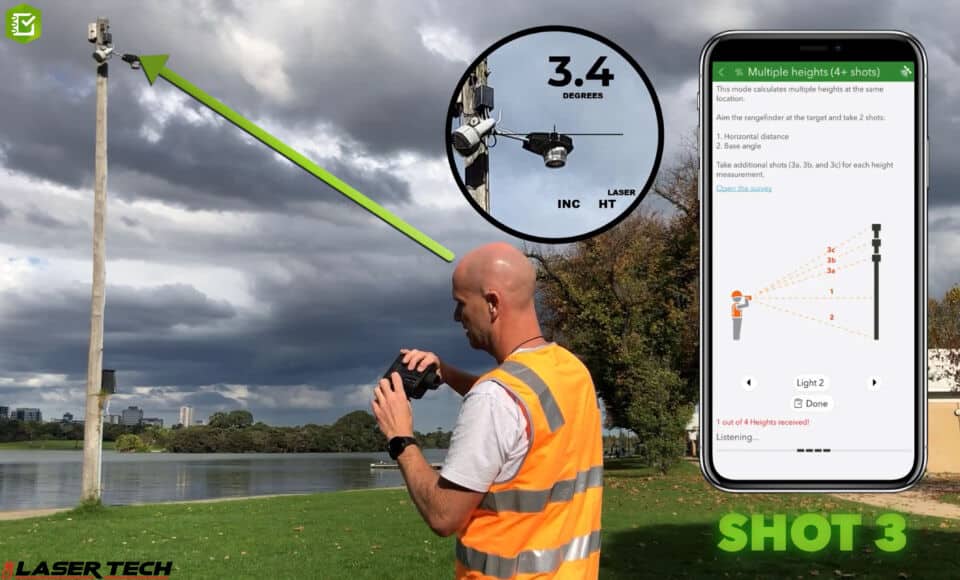
Integrate TruPulse rangefinders with ArcGIS Survey123 to capture multiple heights from one location.
The ArcGIS Survey123 app offers workflows for users to get the most out of integrated rangefinder abilities.
- remotely map assets
- accurately collect heights, depths, distances, clearances, and slope grades
- measure and record multiple target heights on one asset
Increase Your Safety
Pick a safe location with your target in sight to remotely capture measurement data and map asset coordinates.
- Steer clear of hazardous terrain to avoid slips, falls, and related injuries
- Stay out of dangerous areas like busy roads, construction sites, etc.
- Avoid trespassing when assets are located on private property
Boost Your Efficiency

Remote mapping features allow TruPulse and ArcGIS Survey123 users overcome gnss signal issues.
Pick a convenient location that has multiple targets within sight and check them off your list one by one.
- Cut down on your traverse time
- Shrink your crew size/personnel requirements
Overcome Signal Issues
If mapping assets in GNSS signal-impaired areas, just log an origin point and let the rangefinder do the rest. Use a receiver to capture a solid signal connection with your asset in sight/range, then aim and shoot. Sometimes, established coordinates of landmarks or monuments can be used as origin points as well.
Resources for Getting the Most Out of Survey123 Rangefinder Workflows
These resources will help you optimize your experience and results using TruPulse rangefinders with ArcGIS Survey 123:

ArcGIS Survey123 prioritizes user productivity.
- Make sure you nail your setup before heading out into the field with this Esri Help Topic: Prepare for rangefinder data collection in ArcGIS Survey123
- Use the Esri Get Answers Page: Using Laser Rangefinders with ArcGIS Survey123 as a go-to guide for FAQs
- Catch up with the ArcGIS Blog: What’s New in ArcGIS Survey123 (June 2023) for the latest in ArcGIS Survey123, including TruPulse rangefinder integration
- Use this how to video from ArcGIS Survey123 team to introduce yourself to the abilities of integrating TruPulse rangefinders with ArcGIS Survey123 ⬇️
The post ArcGIS Survey123 TruPulse Workflows Boost Productivity appeared first on Laser Tech.
]]>The post MapSmart Volume Training: Restore Culverts & Measure Pits appeared first on Laser Tech.
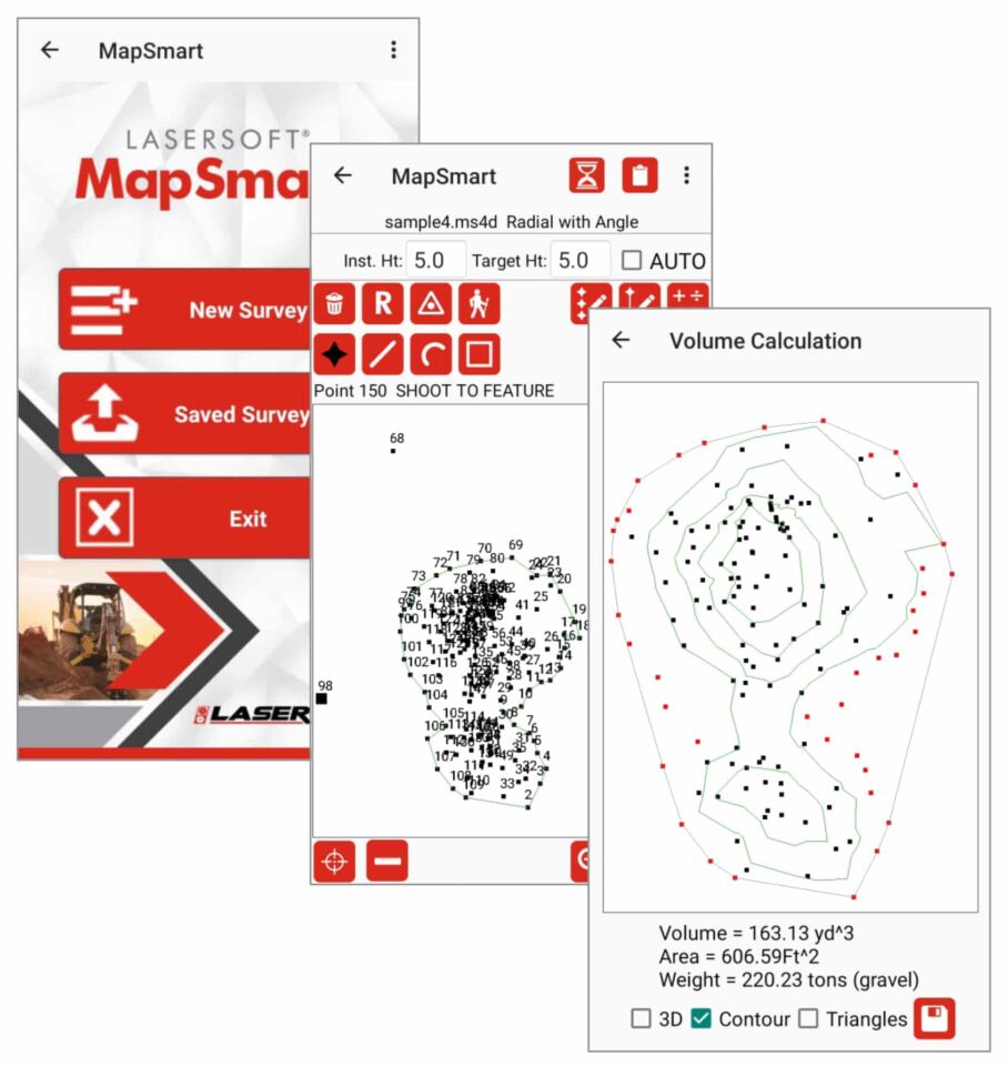
]]>Laser Tech’s (LTI) Application Training Specialist offers a streamlined overview of basic MapSmart volume training. The quick, easy, and accurate workflow uses two examples for volume assessment via our LaserSoft MapSmart data collection app and TruPulse laser rangefinders.
Receive the Full Training Document as a PDF
MapSmart Volume Training: Overview/System Components
Distance
• Pulse laser using time of flight
• Measures directly to any type of surface
• Will discriminate a prism target
Inclination
• Measures vertical angle from the horizon
• Used to calculate Horizontal Distance for XY positioning
• Used to calculate Vertical Distance for Elevation (Z)
Azimuth
• Compass bearing from Magnetic North
• Direction and HD are used to locate a point
• Effected by local distortion to Earth’s magnetic field
Horizontal Angle
•Measures horizontal angle from a known reference
• Direction and HD are used to locate a point
• Not influenced by Earth’s magnetic field
LaserSoft MapSmart app
•Fully functional data collection tool
• Onboard Volume routine
• Measure in minutes
• Immediate results
MapSmart Volume Training: Culvert Restoration
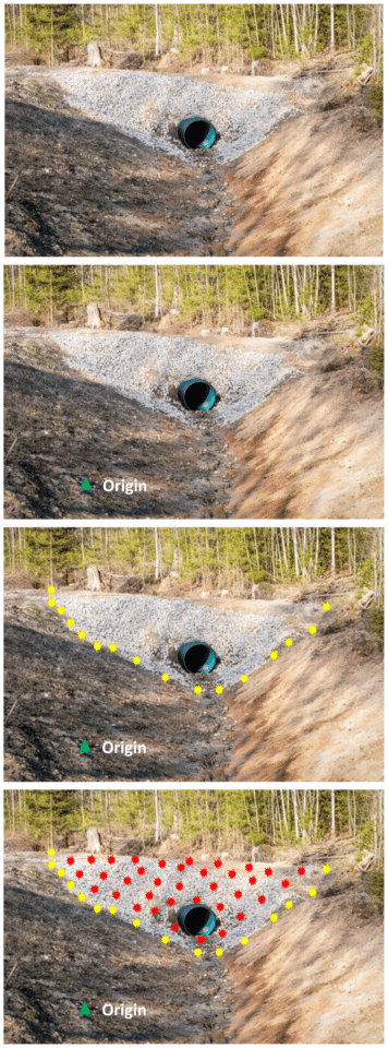
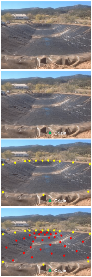
These images help provide a visual reference for MapSmart volume training via culvert restoration.
Assess the site
• Select a suitable place for the starting instrument position, or Origin, where you can see most of the culvert fill
• Make sure you can shoot to a second point that may be necessary to see all of the fill
Measure the Culvert
• Set the Origin or starting Control Point
• Put a temporary mark in the ground at the Origin and set the laser system up over it
• Start a New File and select either a ‘Volume with Azimuth’ or ‘with Angle’ survey
• Enter an accurate height for the laser Instrument above the mark on the ground
• The target height will typically be 0.0 when shooting directly to the surface
• Accept the default values of 0,0,0 for the Origin and reference the angle, if used
Culvert Fill Volume Workflow
• With the Base shot icon highlighted, shoot in the points (yellow)
• Follow the line of separation between the fill and the existing ground
• Shoot in more points where the line changes direction often, fewer where it is straight
• Make sure to measure points at all major breaks in slope and direction
• Tap the Pile icon and shoot in points on the material (red)
• Make sure to get good coverage and take points at all the breaks in the slope
• If another instrument position is required, tap the Create New CP button
• Move the system to the other side and use the same workflow to map in the base and pile points
MapSmart Volume Training: Pit Volume & Reclamation
These images help provide a visual reference for MapSmart volume training via pit volume measurements.
Assess the site
• Select a suitable place for the starting instrument position, or Origin, where you can see most of the pit
• Make sure you can shoot to a second point that may be necessary to see all of the pit
• Set the Origin or starting Control Point
• Put a temporary mark in the ground at the Origin and set the laser system up over it
• Start a New File and select a ‘Volume with Azimuth’ or ‘with Angle’ survey
• Enter an accurate height for the laser Instrument above the mark on the ground
• The target height will typically be 0.0 when shooting directly to the surface
• Accept the default values of 0,0,0 for the Origin and reference the angle, if used
Pit Volume Workflow
• With the Base shot icon highlighted, shoot in the points (yellow)
• Follow the topmost edge of the pit before the slope breaks down
• Shoot in more points where the line changes direction often, fewer where it is straight
• Make sure to measure points at all major breaks in slope and direction
• Tap the Pile icon and shoot to points down in the pit (red)
• Make sure to get good coverage and take points at all the breaks in the slope
• If another instrument position is required, tap the Create New CP button
• Move the system to the other side and use the same workflow to map in the base and pile points
Reports
Generate a Volume Report
• When complete, tap the Calculate button and choose Volume
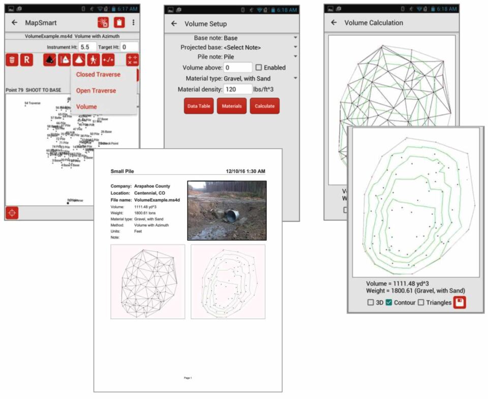
The final step in MapSmart volume training is to analyze the results.
• Select a Material type if the tonnage is desired and tap the Calculate button to view the fill or pit volume result
• Uncheck the Triangles box to view the Contour map only
• Make sure the shape looks correct and that nothing is out of place. This gives you confidence in the result.
• Tap the Save button to generate a PDF report
Receive the Full Training Document as a PDF
Laser Technology, Inc. (LTI, Laser Tech) is a company devoted to the design and manufacture of innovative laser-based speed and distance measurement instruments, using ISO-compliant and continuous improvement techniques.
The post MapSmart Volume Training: Restore Culverts & Measure Pits appeared first on Laser Tech.
]]>